
3.5" Sunlight-Readable TFT-LCD | 10Hz Multi-GNSS GPS | 200Hz 9-Axis Sensor | 10cm 1000Hz Baro | Open Source Modules | Up to ~26h | IPX7
Check on Kickstarter


Modular Multi-sport GPS Computer

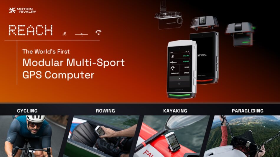
REACH is a 3.5-inch sunlight-readable modular GPS computer. At launch, it supports rowing, kayaking, canoeing, cycling, and paragliding, each with its own dashboard, sensor profile, and metrics, with more sports arriving through OTA updates.
A module is hardware, not a software mode. Snap a module on, and the device gains a capability it didn't have: walkie-talkie, wind meter, camera, and radar. The connector spec, schematics, and pinout are open source. What REACH measures next is open to the entire developer community.
Hear From the Pros


Most sports GPS computers lock their features at the factory. REACH doesn't. Built around a flexible modular architecture, it adapts to your needs rather than forcing a fixed feature set. Specialized modules attach to one universal port, expanding what your unit can measure.


Fully loaded, REACH and all four modules cost $537. Replicating that with standalone devices costs over $3,000. That gap is not a discount. It is the math of modularity. Stop paying for a duplicate screen, battery, GPS, and processor on every single device.


Five disciplines at launch. More dedicated sport modes coming later through OTA updates. Each features a dedicated dashboard, sensor profile, and its own accuracy model — never just a relabeled version of the same screen.


CYCLING


8 tiles on a 3.5" sunlight-readable screen all at once, filled from 30+ data fields: speed, power, VAM, TSS, intensity factor, variability index, heading, balance, etc. Build the layout for the ride you're actually doing, then leave it alone. No mid-ride menu diving or fighting with rigid presets.

Real tile maps on board with 50+ countries at launch, expanding through OTA updates. Load a route, get turn prompts with distance and street name, and share it back out in the same format. Stray off-route and it alerts you.


Most bike computers leave the cadence field blank until you buy the external sensor. REACH tracks it right out of the box. It uses high-precision motion sensors and onboard algorithms to estimate cadence and power directly from your riding dynamics, achieving up to 94% accuracy while climbing, 84–91% cruising, and 81% descending. It also pairs over ANT+ and BLE, so your existing gear still works.


REACH tracks linear acceleration and horizontal angular acceleration simultaneously. By normalizing the metrics, it amplifies the unique signal of your pedal stroke while filtering out road noise.

ROWING · KAYAKING · CANOEING


3.5" sunlight-readable screen with fully customizable 8-tile display. Choose from core metrics like stroke rate, split, power, speed, HR, and distance, or add advanced analytics like heading stability, power curves, and acceleration curves.
The performance-synced LED strip pulses at your target rate. Assign it to stroke rate, split, or heart rate. It glows green while you stay in the zone and shifts color the second you drift out. See it with your peripheral vision, so you can keep your head up and the boat steady.


A wandering boat wastes power going sideways. Heading drift is power you worked for and didn't get. The 9-axis sensor gives an absolute bearing, so it measures your boat's deviation as it happens. You see the raw watts and how many actually drove you faster.
On the paddling side, it scores left and right separately (a Left-Right Balance Indicator), so you see not just that the boat is off line, but which arm is causing it.


Switching hardware usually means relearning how your data behaves. Legacy Mode keeps it where it was. REACH reports with the metrics and display standards your squad already uses: the same SPM and split algorithms, the same landscape layout, the same UI skin. Your logbook from last season stays comparable to the pieces you row today. Switch it off when you want the native metrics instead.


Paddlers have spent years making do with rebranded rowing tech, but the math doesn't translate. Paddling has a shorter stroke, a much higher rate, and far less distance per stroke. REACH runs a separate model for paddling: its own rate range up to 190 spm, custom scoring, real-time left/right balance on screen.

PARAGLIDING


3.5" sunlight-readable screen with 8 tiles for your essential flight data: vario, ground speed, GPS and QNE altitude, and distance. You can also drop in airspeed, glide ratio, landing projections, and multi-layer maps. REACH plots real-time climb and sink trends, so you know if the thermal is building or dying. Set a sink alarm to keep your eyes on the wing, then pin thermals on the map with one press for your next pass, or to share with other pilots.


Contour maps drawn to flight-instrument conventions rather than generic hiking maps. Overlaid on top is a live 360° reachable area computed continuously from wind, your sink rate, height above ground, airspeed, and the contours themselves. Deciding where to land stays yours.


Core a thermal updraft and mark it with one press. The pin stays on your map for the next pass, for future flights, and for the pilots you shared it with. Over a season, a site stops being guesswork and starts being a record, built by the people who actually fly it.

The anemometer module reads the wind where you're actually standing: rotatable head, 0.1 m/s resolution, humidity on the same sensor. The walkie-talkie is multi-channel with an SMA antenna and about 2 km of range. FLARM and ADS-L traffic awareness systems are currently under development.


Compare REACH to the gear you would actually buy. On a bike, in a boat, or under a wing, it replaces several single-purpose devices with one core and clip-on modules. The price difference comes from buying one modular computer instead of three loadouts.

Hardware · Display


Most traditional devices trade color for sunlight readability and settle for a monochrome panel. REACH uses a Blanview LCD instead, and keeps full color even in direct sunlight.


At 3.5 inches and 640 × 960 resolution, REACH outperforms standard sports GPS computers in readability. It delivers crisp, high-contrast clarity, giving you an extra row of metrics you can easily read from arm's length.


REACH delivers 16 million colors for rich maps and vibrant training zones, outperforming the 64-color limit of legacy transflective screens. Drawing a mere 50mW, REACH eliminates the massive battery drain of standard transmissive displays that must burn through 800mW for the exact same sunlight readability.


In direct sun, Blanview LCD delivers superior contrast at any given brightness level compared to legacy screens. This optical efficiency is exactly how REACH stays sunlight-readable at 50mW, while standard transmissive panels burn through 800mW.


Hardware · Positioning


Powered by a 10th-generation u-blox GNSS chip, REACH locks onto multiple satellite constellations simultaneously at a 10Hz refresh rate. More satellites in view means a tighter fix, which means more precision.


Most computers manage 1-2 updates per second. REACH runs at 10Hz. Your on-screen data matches your physical effort, eliminating the lag of rolling averages. It draws under 15 mA while doing it, compared with around 49 mA for a typical GPS. Ten times the precision, zero battery anxiety.


Position is accurate to 2.0m (CEP50) and speed to 0.1m/s. Alongside the GNSS chip, REACH also packs a complete onboard sensor array — accelerometer, gyroscope, magnetometer, and barometer. Those sensors measure heading, motion, and altitude directly in real time rather than deriving them from the GPS alone.

Hardware · Endurance


A 2900 mAh cell runs up to about 26 hours, against 1500 mAh in a typical cycling computer and 970 mAh in a rowing computer or vario, which run around 15 and 8 hours. That is a double day with the drive home still on the battery, or a multi-day trip without carrying a power bank.


The body is rated IPX7, so you don't have to worry about rain, spray, or a drop in the water. It can withstand temporary immersion in up to 1 meter (about 3.3 feet) of water for up to 30 minutes. The chassis is cast as a single piece, so it has fewer seams to open and less to flex.


REACH fits the mounts you already own. It uses an adaptive plate system to retrofit into your existing setup:
On the Bike: Standard quarter-turn base compatible with standard cycling mounts.
On the Water: Includes a rail-mount backing designed for rowing, kayaking, and canoeing brackets.
In the Air: Universal base plate attaches to flight decks, leg straps, or alternative cockpits.


Advanced Analytics with Companion APP

Our dedicated companion app pairs over Bluetooth LE. Every session exports as .FIT, .GPX, .CSV, .IGC or goes straight to Strava. Whatever you decide about REACH in two years, the history comes with you, in formats the tools you already use can open. Lay out your device pages in the app. New metrics and new sport profiles land on the device via OTA firmware updates.


REACH isn't a closed ecosystem. The schematics and pinout for the connector are open-source and free. If you want a module that doesn't exist yet, you have what you need to design, prototype, and build it. REACH isn’t just a sports GPS computer; it's a decentralized, community-driven hardware project built to break traditional manufacturing limits and grow alongside the global athletic community.

Specifications


What's in the Box?


*Note: White and Black are available at launch. Orange and Amber will be unlocked at a milestone goal. Backers can choose their color prior to shipping via a dedicated survey.


